Subscribe to get the guide sent to your email HERE
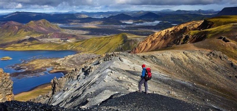
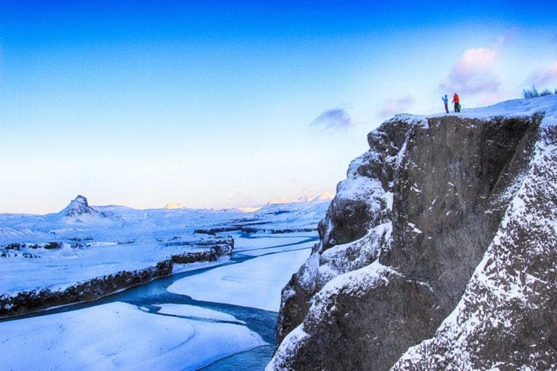
The Laugavegur Hiking Trail is Iceland’s most famous hiking trail and truly one of the world’s most beautiful treks. The trail connects the Landmannalaugar and Þórsmörk Nature Reserves and offers various landscapes. There are different views of beautiful, pristine nature every day, with volcanic mountains, lava fields, glaciers, natural hot springs, black arctic deserts, and lush forested valleys.
The Laugavegur Hiking Trail has been described as one of the best treks in the world by publications such as National Geographic and the Lonely Planet, as well as by individual hikers and adventure writers.
The Laugavegur Hiking Trail is located in the southern highlands of Iceland, north of the infamous Eyjafjallajökull Volcano. Most people traverse the 55-kilometre-long Laugavegur Hiking Trail in 3 – 5 days, trekking from north to south starting in Landmannalaugar and ending the trek in Þórsmörk. The 24 – 30-kilometre long Fimmvörðuháls & Eyjafjallajökull hiking trail can be added to the trek, connecting the Laugavegur Trail with Skógar on the south coast of Iceland.
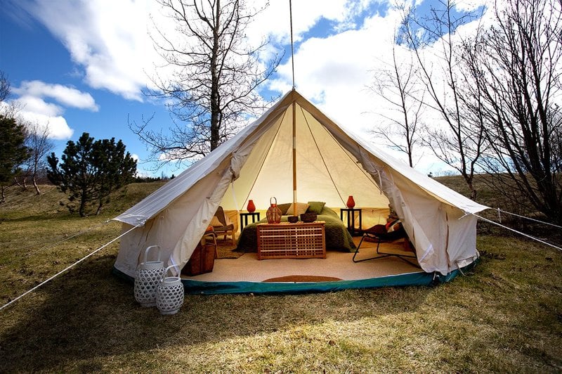
Huts and camping sites along the Laugavegur trail are usually open from the end of June until the end of August, depending on snow and trail conditions. The Volcano Huts in Þórsmörk stay open all year, offering accommodation, catering and outdoor activities.
Daily scheduled busses drive between Reykjavík and the starting and endpoints of the trail in Landmannalaugar and Þórsmörk. The bus stop in Þórsmörk is here at the Volcano Huts in Husadalur Valley in Þórsmörk.
The Volcano Huts offer affordable packages for hikers wanting to trek the Laugavegur Trail, including bus tickets, accommodation and other services.
Volcano Trails operates a restaurant by the Álftavatn camp on the Laugavegur Hiking Trail. The restaurant is at the second camp on the trail about 24 kilometres from Landmannalaugar and 12 kilometres from the Hrafntinnusker hut. The Álftavatn Restaurant is open daily from 11:30 -23:00 and serves lunch, dinner, snacks and drinks at the bar.
Daily scheduled busses drive between Reykjavík and the starting and endpoints of the trail to Landmannalaugar and Þórsmörk. Highland bus tickets to the start of the trail and back to Reykjavik from the end of the trail in Þórsmörk or Skógar are included in the standard Laugavegur Trail offer.
Busses leave every day during the season for Landmannalaugar and Þórsmörk from the BSI Bus Terminal in Reykjavík at 7:00 and at 15:00 (later departure only available in between specific dates).
Busses back to Reykjavik leave Þórsmörk every day during the Laugavegur season.
Click here to view the bus schedule and book tickets.
Busses can be boarded at Skógar (usually at 10:15) if you intend to hike over the Fimmvörðuháls pass.
A new restaurant is now open by the Álftavatn camp on the Laugavegur Hiking Trail. The restaurant is located in the second camp on the trail about 24 kilometres from Landmannalaugar and 12 kilometres from the Hrafntinnusker hut.
The Álftavatn Restaurant is open daily from 11:30-23:00 and serves lunch, dinner, snacks and drinks at the bar.
The next restaurant is the Lava Grill and Bar at the Volcano Huts in Þórsmörk at the trail's end. It is open between 8:00 and 23:00 and offers breakfast, lunch, dinner, lunch packs, coffee & tea, snacks, soft drinks, and alcoholic drinks at the bar.
A small shop is also located at the Volcano Huts in Þórsmörk, which sells candy, pasta, rice, dry foods, homemade bread, sanitary products and other necessities.
Hikers will have to carry their food along the way.
Cold running water is available at all stops. Any water in rivers, streams, pools, and snowmelt is suitable for drinking, even though it is grey or brown from carrying a little bit of silt or soil with glacier water.
Huts and camping sites along the Laugavegur trail are usually open from the end of June until the end of August, depending on snow and trail conditions.
The Volcano Huts in Þórsmörk are open most of the year, and visits to Þórsmörk are possible when the Laugavegur Trail is closed.
In springtime, some parts of the Laugavegur Hiking Trail can be covered in snow, while others might be wet and muddy as the ground thaws. Markings and waypoints might also be under snow or washed away in floods during the spring melt.
During the summer, you will most likely have good weather conditions and experience 24 hours of daylight. Between the second weekend of July and the second weekend of August, you will have the most traffic on the trail.
The huts along the trail are not serviced in the fall, but camping is permitted. In good conditions, the fall is a lovely time to do the Laugavegur trek with fewer people on the trail. Dusk starts to creep in around midnight in the second half of July, and by September, the nights are pitch black, and there are no lights in the highlands, so you might want to bring some lights with you. The climate starts to get cold by the end of August, and you may experience frosty conditions.
The weather in the Icelandic highlands can be unpredictable. Very strong winds, heavy rain, hail, and even snow can occur with little warning. Always check the weather forecast and ensure your equipment and clothes stay dry in your pack.
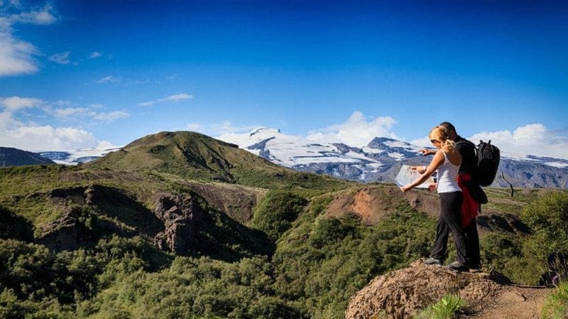
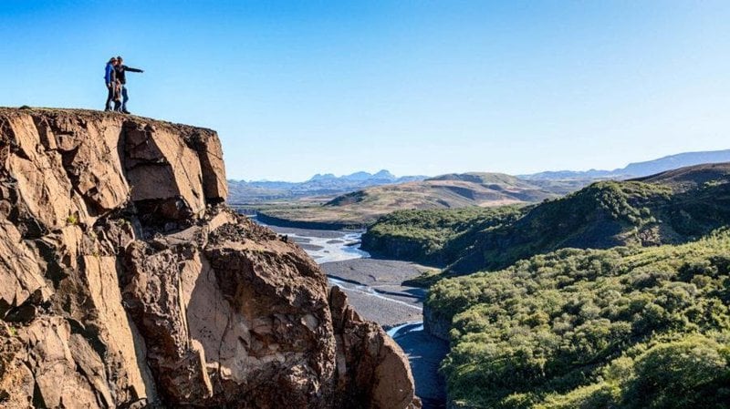
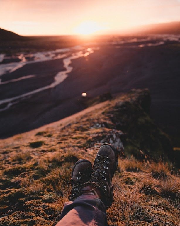
The Laugavegur Hiking Trail offers a variety of landscapes along the way. Every day, you will see different views of beautiful, pristine nature, including volcanic mountains, lava fields, glaciers, natural hot springs, black arctic deserts, and lush forested valleys.
The trail is suitable for most hikers, but the terrain can be demanding in some areas, with steep hills, unbridged rivers, and snowy conditions. During the high season, many people start the trek every day, and help is usually not far away on the trail. During other seasons, it might be days before someone wanders past your area.
Camping sites offer little shelter; in some areas, there is little or no hold for tent pegs to secure your tent.
The trail starts/ends at 600 meters above sea level in Landmannalaugar and reaches up to 1.100 meters on the first/last day. The trail ends/begins in Þórsmörk, about 200 meters above sea level.
The weather in the Icelandic highlands can be very unpredictable. Very strong winds, heavy rain, hail, fog, and even snow can occur with little warning. Always check the weather forecast and ensure you stay warm and your equipment and clothes stay dry in your pack.
Icelandic Met Office
Safetravel.is
Your clothing and equipment can make or break your trek along the Laugavegur Hiking Trail. Do it correctly and you will ensure your safety and maximize your comfort, but get it wrong you make the trek much harder and may even endanger yourself and others.
Dressing in layers means you can take off or put on more layers to control your body temperature.
Inner layer: Wear wool or other insulating materials next to your body—underwear and bras included. This keeps you warm and removes moisture.
Second layer: Fleece or other lightweight materials
Outer layer: Wind and waterproof with some breathing or ventilation – Gore-Tex or similar
Bring one set of clothes to walk in and another dry set to change into at night. It is not always possible to dry clothes in the huts.
Do not wear cotton clothing, such as jeans, T-shirts, socks, and sweatshirts. Cotton absorbs moisture and sticks to your body, keeping you wet and cold.
The following is a list of things to bring along. How much of everything is up to you. Some may want to travel light, while others are comfortable carrying heavier packs.
The Laugavegur Hiking Trail is a rewarding trek in good conditions, but remember that weather, bad luck and insufficient preparation can change your journey into a bad experience. Mobile service is available in some parts of the trail but is very limited in others. Electricity to charge mobile phones is unavailable except at the Volcano Huts in Þórsmörk.
Weather is a deciding factor and can change very quickly. Very strong winds with heavy rain, hail, fog, and even snow can occur with little warning. A sudden change in weather may cause a severe drop or rise in temperature. Always check the weather forecast and make sure that you stay warm and that your equipment and clothes stay dry in your pack.
Most outdoor-related fatalities in Iceland are related to cold and bad weather, resulting in hypothermia.
Sudden rain or rise in temperature may cause flash floods in streams and rivers. Wait for other travellers to come by if you are unsure about crossing a river. Learn how to cross rivers before you go. Google it, then practice!
Wandering away from the trail can be rewarding in some places, but be sure to find your way back to the marked trail. Make sure someone knows about your travel plans and remember to stick to the plan or inform someone about changes to your plan.
We strongly advise all travellers to list their travel plans online with Safetravel.is and even download the Icelandic emergency App 112 for smartphones.
You can also sign your name at a safety list in all the huts along the trail but listing with Safetravel.is is a far better way to ensure your safety.
Because of the unique nature of the Laugavegur Hiking Trail, thousands of hikers worldwide come to experience its wonders. We all want to experience it in its most natural and unspoilt condition, so let's try to make as little impact on its nature as possible. The soil and vegetation in the Icelandic highlands are incredibly fragile and any damage to it can cause massive erosion and take years to heal.
Tread lightly and stay on the path, don’t litter and respect the land. It's as simple as that!
Share your tips, tricks and stories about how to minimize the impact on nature on our Facebook page.
The Laugavegur Hiking Trail is usually done in 3 – 5 days and in 3 – 4 stages where travellers stay in huts or camp along the trail. You can make your own version and skip stages or stay longer in certain places and go for walks around areas of particular interest to you. Keep in mind your personal fitness and capabilities and remember that this time it really is the journey and not the destination that matters. Enjoy the trek and soak in the natural beauty of the trail.
Times are approximate and will vary according to fitness, the pace of group and weather conditions.
If you intend to do a shorter version, we recommend combining the first two days in one stage (Landmannalaugar – Álftavatn, 22 km) or the second and third days (Hrafntinnusker – Emstrur, 27 km).
Starting the trek from – Landmannalaugar brings you to an easy hike through the lava field of Laugahraun towards the colourful mountain Brennisteinsalda. There you start a gradual climb through dissected hills with views of an incredible spectrum of colours. After 3 – 4 hours you should arrive at the Stórihver geothermal area and hot springs. About 2/3 of the way is likely to be covered with snow until late summer. At an elevation of around 1.000m, you can expect fog to show up suddenly and without warning. The trail is clearly marked but hikers must be careful not to lose the track in poor visibility.
Hrafntinnusker Hut (Höskuldsskáli) will appear suddenly about 2 km past a memorial of a traveller, who sadly died of hypothermia in this area in June 2004.
Evening walks from the Hrafntinnusker hut: 20-minute walk to Mt. Söðull (beautiful views) or 40-minute walk to ice caves. Ask warden for more information.
Heading out from the Hrafntinnusker hut, the trail takes you through a valley with small ravines that sometimes may be filled with snow. A short, steep incline leads you to the highpoint of today’s walk. If the visibility is good, a side trip to the summit of mountain Háskerðingur (1.281 m) will reward you with a breathtaking view. This is best done from the western slope of the mountain. But take care as you have to cross a glacier on the way. Ask the hut warden for further information.
Soon after, you will leave the colourful rhyolite mountains and enter an area that contrasts dark palagonite mountains with white glaciers. You will also notice a considerable increase in vegetation. The trail down the Jökultungur is quite steep and care must be taken during the descent. The last few kilometers to the huts by the lake Álftavatn are on flat land. The two huts at Álftavatn take up to 52 persons.
Evening walks: Hike up Mt. Brattháls, which takes 1 – 2 hours return. Wet feet are included as it’s necessary to wade the little stream running from Lake Álftavatn. Another good hike takes you up the Mt. Torfatindur (818m), estimated walking time 1 – 2 hours.
The trail leads you over the Brattháls Ridge into Hvanngil Ravine, wading across the small Bratthálskvísl River. In the Hvanngil Ravine, you will find two huts, one built for sheepherders in 1963 and one for tourists, built in 1995. As Álftavatn and Hvanngil are only 5 km apart, Hvanngil can be used as an alternate accommodation. The huts have toilet facilities, showers and a small camping site in an old lava field.
Leaving Hvanngil you cross a bridge over the Kaldaklofskvísl River. On the eastern bank of Kaldaklofskvísl River, the trail splits in two. You should take the path leading south to Emstrur and Þórsmörk. The other branch leads east to Mælifellssandur (Road F 210). Soon after that, another river has to be waded.
For a few kilometres, the Laugavegur Trail joins a mountain road. You can stay on the road all the way to the Emstrur hut or take a hiking trail alongside the road.
You will have to cross the powerful Nyrðri Emstruá River on a bridge that the road will take you to. After crossing the bridge you will traverse a few kilometres on flat land until you suddenly find the Botnar huts in Emstrur.
Evening walk: Markarfljótsgljúfur canyon is a 40 to 90-minute hiking tour with beautiful views of the canyons and neighbouring mountains.
In about 45 minutes, after heading out from the Emstrur huts, you should be on a steep path leading towards the canyon of Syðri-Emstruá River. The river can be crossed on a hiking bridge in a narrow part of the canyon, with the river raging beneath your feet. From the canyon, you will walk through a hilly area known as Almenningar with the first view of Þórsmörk insight. At the end of Almenningar, you will have to wade the Þröngá River, the last unbridged river on the Laugavegur Trail. The Þröngá River usually runs in multiple small streams along the valley floor and is relatively shallow unless during heavy rainfall. When wading, it is good practice to go hand in hand and head downstream or to use hiking poles to keep your balance. After crossing the Þröngá River, you will enter the forested area of Þórsmörk. Follow the path to an intersection with signs that show directions to different huts in Þórsmörk. From there, you should reach the Volcano Huts in Húsadalur Þórsmörk or Langidalur hut in 30 minutes.
Evening walks: In Þórsmörk, you will find many possibilities for evening walks, such as the Þórsmörk Panorama Trail to Mt. Valahnúkur or a short walk to the Sönghellir Cave.
Huts and camping sites along the Laugavegur Hiking Trail are open from the end of June until the middle of September, depending on snow and trail conditions.
Most people travel from north to south, from Landmannalaugar to Þórsmörk and do the trek in 4 stages. That way you would start in Landmannalaugar and stay at the huts in Hrafntinnusker, Álftavatn, Emstrur and Húsadalur in Þórsmörk at the Volcano Huts.
Huts and camping grounds are located in the following areas
The huts along the way are basic mountain huts with sleeping bag accommodation in dormitories. All the huts have toilets, showers and basic cooking facilities. The Volcano Huts in Þórsmörk open earlier in the spring and stay open longer into the fall.
At the Volcano Huts in Þórsmörk, you will find a restaurant & bar, natural hot pool and sauna, private and shared accommodation and a camping site. The Þórsmörk bus station is at the Volcano Huts.

 +354 419 4000